
OUR SERVICES

Topographical Surveys, R/W Plan Development, R/W Acquisition Mgt INDOT Prequal 6.1, 12.1, 11.1
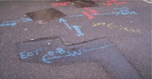
Topographical surveys are completed in order to obtain all existing ground features and elevations. All existing ground features are located, and the Indiana Underground Protection Services is contacted to have all utilities within the area located. Once these utilities are marked in the field Northpointe locates these utilities to be shown on the survey. Northpointe also contacts all utility companies within the area to obtain utility maps showing their utility locations. Topographic surveys include storm and sanitary sewers, manholes and inlets, including the depths and sizes. Topographical surveys are based upon a USGS Benchmark and will show spot elevations along with contours with one-foot intervals. The base survey is enhanced with legal rights of way information with existing plat and deed information for recording and acquisitions. We have staff to simultaneously run five(5) full time survey crews
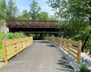
Roadway Design / Trail Design / Sidewalk & Ramp Design INDOT Prequal 8.1
Roadway designs are completed in line with the INDOT manual and our team encourages client interaction and approval for every stage. Every design includes a thorough review of utilities and possible conflicts with other projects. This effort includes public and private utilities, traffic control, adjacent right of way, adjacent local agencies and stakeholders, drainage, and value engineering. We are well experienced with single lane and multilane roadways, geometrics, roadside safety features, signage, clear zone, super elevations, and intersection improvement.
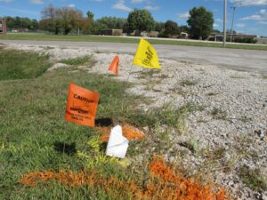
Sub-Surface Utility Engineering & Utility Coordination & Railroad Coordination INDOT Prequal 16.1
Providing subsurface utility engineering (SUE) and utility coordination for your project. This scope of service will be tailored to a project need and deliverables and may include utility coordination per INDOT manual, and SUE per ASCE guidelines. During SUE, the utilities will be designated as quality levels A, B, C, or D and a report will be provided. This service may also include ground penetrating radar investigations and test holes depending on the complexity of a project. Utility Coordination following the INDOT manual will continue through a work plan being completed, which in many instances will carry over into the construction portion of a project. Our team’s experience includes successfully completing over thirty of these type projects within the past nine months.
Construction Engineering (Inspection, Layout and Staking) INDOT Prequal 6.1, 13.1
Northpointe provides Construction Engineering / Layout services for Contractors on INDOT projects. The services include checking proposed plan data for Horizontal & Vertical accuracy such as cross-sections. Provide Base-line and offset control, Benchmarks, construction staking of Bridges, Cable Barrier Systems, Roadways, Storm Sewers, Sanitary Sewers, Traffic Signal Poles and various other Infrastructure improvements as well as assist in the identification of site issues which require data collection, calculations and solutions.
Providing Construction Inspection, Management and Administration services for construction for Roadways, Bridges, Traffic Signalization, Trails & Greenways, Water, Sanitary and Storm Sewer Projects. Northpointe offers a staff of highly experienced engineers, inspectors and technicians having been trained and certified in various categories needed for the diverse field in today’s construction technologies including INDOT Site Manager.
Site / Civil
Utility & Infrastructure
Water & Wastewater Systems -
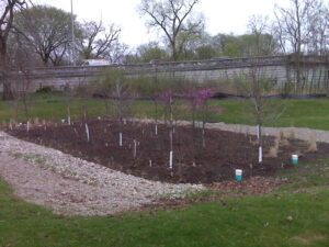
Site Development -
Sustainable Design -
Hydrology, Hydraulics & Drainage -
Utility Coordination -
Permitting -
Erosion & Sediment Control
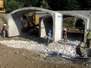
Pedestrian Bridges
Retaining Walls -
Feasibility Planning for Residential & Commercial Developments
Transportation
Road Reconstruction or Rehabilitation - Intersection Improvements - Roundabout Design - Traffic Signal & ITS & ATMS & Preemption Design - Trail & Sidewalk Design - Drainage Improvements - Utility Coordination and Railroad Coordination & Subsurface Utility Engineering & Potholing - Maintenance of Traffice - Roadway Sign Design - PASER Rating Studies - Pedestrian Bridges - Retaining Walls
Environmental
IDEM 401/404 Permitting - General Permit (Rule 5) - DNR Wetland Mitigation - SWPPP – Stormwater Pollution Prevention Plans - SWQCP – Stormwater Quality Control Plans
Survey
Governmental
Topographical Design Surveys -
Location Control Route Surveys -
Right of Way Engineering -
Bridge Survey
Private
ALTA/PLS -
Original Retracement Survey -
Construction Layout -
As-Built -
Easement Preparation
Platting
Specialty Services
Survey Scanning -
Bathometric Survey
Computer Software
AutoCAD Civil 3D -
AutoCAD with Carlson Design/Survey -
Microstation (INDOT Setups) -
Trimble Business Center
Equipment
Trimble Dini (Electronic Level) -
Trimble S5 (Robotic) -
Trimble SX10 (Scanner) -
Trimble R12i GPS -
Trimble Data Collector TSC7 -
Spectra Precision SP80/85 GPS -
Ranger SX800 UTV -
Watercraft for River/Lake Survey -
GPS Camera
Construction Inspection
Site Inspection and Asbuilt Survey Anchor Bolt / Column - Resident Project Representative - INDOT Site Manager - Materials Testing - Bridge Rehabilitation - Road Reconstruction - Intersection Improvements - Utility Engineering (Wastewater, Water, Storm) - Pipe Lining - Residential / Industrial Development - Site Management
INDOT
CERTIFICATION
INDOT PREQUALIFICATION
6.1 Topographic Survey Data Collection
8.1 Non-Complex Roadway Design
11.1 R/W Plan Development and R/W Engineering
12.1 Project Management for Acquisition Services
13.1 Construction Inspection
16.1 Utility Coordination and Railroad Coordination Certified
Storm Water Management / SWPPP & SWQCP Plans & Inspection
INDOT Inspection Site Manager
INDIANAPOLIS CERTIFICATION
